A new journal paper co-authored by members of the S4H team has been published in Seismological Research Letters. The study, authored by Dr. Shaghayegh Karimzadeh and Prof. Paulo B. Lourenço, in collaboration with Mr. Alejandro Cruz, Mr. Mohammad Ghasemi, Assoc. Prof. Sadra Karimzadeh, Prof. Aysegul Askan, and Prof. Masashi Matsuoka, presents a detailed multidisciplinary assessment of the 28 March 2025 Myanmar earthquake (M 7.7). The event ruptured the right-lateral Sagaing Fault, producing intense shaking across central Myanmar and was followed by a strong M 6.7 aftershock twelve minutes later.
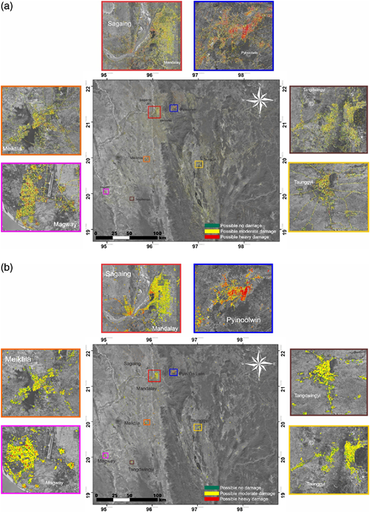
The study integrates strong motion data, macroseismic intensity observations, liquefaction evaluation, and ALOS-2 ScanSAR remote sensing to characterize the earthquake’s effects. Results show supershear rupture propagation over ~460 km, with clear fault‐directivity patterns and horizontal PGA values up to 0.57g, exceeding Myanmar’s national design levels, particularly affecting low-rise structures.
Widespread liquefaction was observed near the Irrawaddy River, corroborated by correlations between cumulative absolute velocity (CAV) and liquefaction probability maps. Advanced SAR coherence analysis identified extensive building and infrastructure damage, with over 39,000 km of roads and numerous urban zones exhibiting moderate to heavy losses.
This work highlights the value of joint ground motion analysis and satellite-based damage detection for rapid post-earthquake assessment, contributing to improved resilience and seismic-risk management in the region.
For the full paper, please visit this link.
Share this post